How did WWII pilots navigate without GPS
The Ingenious Methods That Guided Them Through War
Imagine climbing into a B-17 Flying Fortress on a moonless night in 1944. Your target lies hundreds of miles away beyond enemy territory. There is no GPS, no moving map display, and no satellite navigation. A wrong turn could leave your aircraft hopelessly lost over the North Sea, out of fuel over the Pacific, or directly in the path of enemy defenses.
Yet during World War II, thousands of Allied and Axis aircrews routinely crossed oceans, navigated through storms, found targets in darkness, and returned home. How did they do it?
The answer involved a remarkable combination of maps, mathematics, celestial navigation, radio signals, and some of the most advanced technology of the era. Long before satellites guided aircraft around the globe, wartime navigators relied on skill, training, and ingenuity to find their way through the world’s most dangerous skies.
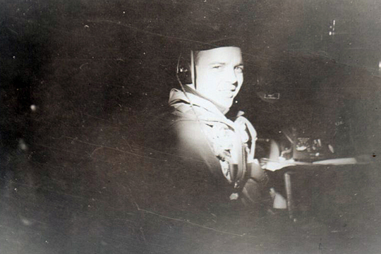
B-29 Navigator Paul Downey in 1954. |
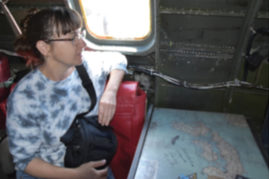
Patricia Downey, Paul's daughter recreates photo in B-29 FIFI in 2019. |
How Did WWII Pilots Navigate Using Maps and Landmarks?
The earliest and simplest form of aerial navigation was known as pilotage. The concept was straightforward: compare the landscape outside the cockpit with the features shown on a map.
Roads, rivers, railroads, lakes, mountains, and towns served as navigational checkpoints. If a pilot could identify landmarks on the ground, they could determine their position and follow a planned route.
Pilotage worked well in daylight and clear weather. However, it became far more difficult at night, over water, in poor visibility, or over blacked-out enemy territory where cities intentionally concealed their lights.
As the war expanded across oceans, deserts, and remote regions, pilots needed more sophisticated methods.
What Is Dead Reckoning?
Dead reckoning became the foundation of long-range aerial navigation during World War II.
This method began with several known factors:
* A starting point
* Airspeed
* Compass heading
* Elapsed time
Using these variables, navigators estimated the aircraft’s position at any given moment. Wind complicated the process, however. A crosswind could slowly push an aircraft miles off course without the crew realizing it.
To compensate, navigators used drift meters, wind forecasts, and constant calculations to update the aircraft’s estimated position. This continually updated estimate became known as the aircraft’s “DR position,” or dead-reckoning position.
In large bombers such as the B-17, B-24, B-25, and B-29, navigation was a full-time job. Dedicated navigators maintained flight logs, plotted positions, calculated headings, and coordinated with pilots and bombardiers.
Fighter pilots often had no such luxury. A pilot flying a P-51 Mustang or P-47 Thunderbolt might simultaneously navigate, maintain formation, monitor fuel, watch for enemy aircraft, and fly the airplane.
How Did Celestial Navigation Work During World War II?
When there were no landmarks and no radio signals available, navigators often looked to the sky.
Celestial navigation used the positions of the sun, moon, planets, and stars to determine an aircraft’s location. Using a sextant, navigators measured the angle between a celestial body and the horizon. Combined with precise timekeeping and navigational tables, these measurements allowed crews to calculate their position.
The process was far from easy.
Unlike a ship at sea, an aircraft vibrated constantly and often flew through turbulence and cloud layers. Navigators sometimes had only brief moments to obtain accurate observations before clouds obscured the sky.
Despite these challenges, celestial navigation remained indispensable for transoceanic flights, long-range patrol aircraft, ferry operations, and Pacific combat missions where visual landmarks were scarce.

How Did Radio Navigation Help Pilots Find Their Position?
Radio technology introduced another powerful navigational tool.
By tuning into known radio beacons, aircrews could determine the direction of a transmitting station. Using bearings from multiple stations, navigators could pinpoint their location with much greater confidence than dead reckoning alone.
In areas with developed aviation infrastructure, aircraft could follow radio ranges or home directly to beacon signals. This significantly improved navigational accuracy near friendly territory.
However, radio navigation had limitations.
Signals could be weak, blocked by terrain, jammed by enemy forces, or simply unavailable over vast oceans and remote regions. Enemy intelligence services could also exploit radio transmissions.
For these reasons, navigators rarely relied on a single method. Instead, they combined radio navigation with pilotage, dead reckoning, and celestial observations.
Was LORAN the First Version of GPS?
One of World War II’s most important navigational innovations was LORAN, short for Long Range Navigation.
LORAN used synchronized radio pulses transmitted from multiple ground stations. By measuring differences in signal timing, navigators could determine their position with impressive accuracy.
Unlike modern GPS, LORAN did not provide an instant location on a digital screen. Operators needed specialized equipment, charts, and training to interpret the information.
Nevertheless, it represented a major breakthrough. For the first time, aircraft and ships could navigate accurately across vast distances regardless of weather or visibility.
Many historians consider LORAN one of the most important stepping stones toward today’s satellite navigation systems.
The B-29’s Early Navigation Computer
The Boeing B-29 Superfortress represented the cutting edge of wartime aviation technology.
Among its innovations was an instrument known as the Air Position Indicator, an electromechanical dead-reckoning computer. By continuously processing inputs such as heading and airspeed, the device estimated the aircraft’s position automatically.
While primitive by modern standards, it was an early example of automated navigation and foreshadowed the computerized systems found in today’s aircraft.
The U.S. Navy also developed sophisticated carrier-navigation systems. One highly secret radio-beam network allowed aircraft to locate carriers at sea while preventing enemy forces from identifying the fleet’s location.

How Did British Radar Navigation Systems Work?
Some of the war’s most influential navigational developments came from Britain.
The Royal Air Force introduced several revolutionary systems that dramatically improved bomber operations over occupied Europe.
GEE
GEE used synchronized radio signals to help navigators determine their location. By measuring timing differences between signals, crews could identify their position on specially prepared charts. The system proved invaluable for guiding bomber formations across the English Channel and back.
Oboe
Oboe offered even greater accuracy. Ground stations tracked specially equipped aircraft and guided them toward a target using radio signals.
Because only one aircraft could use the system at a time, the RAF typically employed it on fast pathfinder aircraft such as the de Havilland Mosquito. These aircraft marked targets with flares, allowing following bomber formations to find their objectives.
H2S Radar
H2S radar allowed crews to identify terrain features, coastlines, rivers, and cities on a radar display. Unlike visual navigation, radar functioned through darkness, clouds, and poor weather. It became a critical tool for night bombing operations. These systems transformed the air war. Navigators no longer relied solely on maps and stars; they now had access to electronic tools capable of guiding aircraft through darkness and adverse weather.
The Battle of the Beams: The First Electronic Navigation War
Navigation technology soon became a battlefield in its own right.
German forces developed sophisticated radio-beam systems that guided bombers toward their targets. Aircraft could follow a beam and receive cues indicating when to release their bombs.
British scientists eventually discovered these systems and began interfering with them.
The resulting struggle became known as the Battle of the Beams.
British operators studied German navigation signals, jammed them, distorted them, and sometimes redirected them entirely. The contest evolved into one of history’s earliest electronic warfare campaigns.
What began as navigation had become a secret war of physics, engineering, and intelligence.
What Can Modern Pilots Learn from WWII Navigation?
Despite remarkable technological advances, one lesson from World War II remains relevant today: navigation is ultimately a human skill. Navigators did far more than read maps. They continuously solved complex problems involving weather, time, speed, distance, and uncertainty—often while under enemy attack.
Modern military aircrews still train for GPS outages, electronic warfare, and degraded navigation environments. The U.S. Air Force’s Combat Systems Officers continue many of the responsibilities once carried out by wartime navigators, overseeing navigation, mission planning, surveillance, and weapons employment.
Today’s pilots may navigate using satellites, but the principles developed during World War II remain deeply woven into modern aviation.
The Legacy of WWII Navigation
A smartphone can determine your location almost instantly anywhere on Earth. World War II aircrews had no such luxury.
Instead, they relied on stars, stopwatches, radio signals, maps, mathematics, and extraordinary skill. Whether crossing the Pacific, navigating through European weather, or finding a carrier in the middle of the ocean, these crews accomplished feats that seem almost unimaginable today.
Many of the technologies that underpin modern navigation—from electronic positioning systems to automated flight management—trace their origins to innovations developed during World War II.
GPS may have changed navigation forever, but the foundations were built by the airmen who learned to find their way long before satellites existed.
Like stories like these?

About the Historian
Annie Flodin is an aviation journalist, photographer, and historian based in Fort Worth, Texas. She has worked in the aerospace industry for nearly a decade, including several years as a corporate historian for The Boeing Company. In that role, she collaborated with the Commemorative Air Force on a variety of projects focused on preserving and sharing aviation history. She is currently pursuing her Private Pilot License and hopes to one day fly with the CAF.
Frequently Asked Questions About WWII Navigation
Did World War II pilots have GPS?
No. The Global Positioning System (GPS) was not developed until decades after World War II. Wartime aircrews relied on maps, dead reckoning, celestial navigation, radio beacons, radar systems, and other methods to determine their position.
How did bomber crews know where they were?
Most American bombers carried a dedicated navigator whose job was to track the aircraft's position throughout the mission. Navigators used maps, clocks, compass headings, radio signals, and celestial observations to continuously update the aircraft's location.
What was the most common navigation method during World War II?
Dead reckoning was one of the most widely used navigation methods. Crews calculated their position based on a known starting point, speed, heading, elapsed time, and estimated wind conditions. Most navigators combined dead reckoning with other techniques for greater accuracy.
How did pilots navigate over the ocean during WWII?
Over oceans, landmarks were unavailable, so crews often relied on celestial navigation, dead reckoning, radio navigation systems, and later technologies such as LORAN. Long-range flights across the Pacific frequently depended on star sightings to verify position.
Did fighter pilots have navigators?
Generally, no. Most single-seat fighters such as the P-51 Mustang, P-47 Thunderbolt, and Spitfire relied on the pilot to handle navigation. This required pilots to manage maps, fuel, timing, and navigation while also flying the aircraft and watching for enemy threats.
What is celestial navigation?
Celestial navigation is the process of determining position by measuring the location of the sun, moon, planets, or stars. WWII navigators used sextants, accurate clocks, and specialized navigation tables to calculate their position during long-range missions.
What was LORAN?
LORAN, or Long Range Navigation, was a radio-based navigation system developed during World War II. It used signals from multiple ground stations to help aircraft and ships determine their position with a high degree of accuracy, regardless of weather conditions.
Was LORAN the predecessor to GPS?
While LORAN worked differently than GPS, it was one of the technologies that paved the way for modern electronic navigation systems. Both systems determine position by comparing signals from multiple transmitters, though GPS uses satellites rather than ground stations.
How accurate was WWII navigation?
Accuracy varied depending on weather, equipment, crew experience, and mission type. Skilled navigators could often determine their position within a few miles, but small errors could accumulate over long distances. This is why crews frequently cross-checked multiple navigation methods.
What was the Battle of the Beams?
The Battle of the Beams was an electronic warfare campaign between Britain and Germany during World War II. German bombers used radio navigation beams to find targets, while British scientists developed methods to detect, jam, and manipulate those signals, disrupting enemy bombing operations.
Did navigation technology help win World War II?
Yes. Advances in radio navigation, radar navigation, and electronic positioning allowed Allied aircraft to fly farther, operate at night, navigate in poor weather, and locate targets more effectively. Many historians consider navigation technology one of the key factors that increased the effectiveness of Allied air operations.
Are WWII navigation skills still taught today?
Yes. Modern military and civilian pilots still learn many of the principles used during World War II. Aircrews train for situations involving GPS failures, electronic warfare, and degraded navigation environments, ensuring they can operate even when modern systems are unavailable.
Sources and Further Reading
• Bennett, Ralph. The Battle of the Beams: The Secret Science of Radar that Turned the Tide of the Second World War. London: William Kimber, 1979.
• Boyne, Walter J. Beyond the Wild Blue: A History of the U.S. Air Force, 1947–2007. New York: St. Martin's Press, 2007.
• Pape, Garry. "LORAN: Long Range Navigation." IEEE Global History Network. Accessed June 2026.
• Price, Alfred. Instruments of Darkness: The History of Electronic Warfare, 1939–1945. London: Greenhill Books, 2005.
• Royal Air Force Museum. "Gee Navigation System." Accessed June 2026.
• Smithsonian National Air and Space Museum. "Dead Reckoning." Time and Navigation. Accessed June 2026.
• Smithsonian National Air and Space Museum. "YE-ZB Navigation System." Time and Navigation. Accessed June 2026.
• Van der Vat, Dan. The Pacific Campaign: World War II, the U.S.–Japanese Naval War, 1941–1945. New York: Simon & Schuster, 1991.